[原]OpeanLayers3 For ArcGIS MapServer
2024-09-04 09:04:52
由于OpenLayers3比较新,百度能找到的demo很少,自己不得不参考官方给出的Examples来依葫芦画瓢了,地图服务采用的局方给的ArcGIS MapServer,先上图:
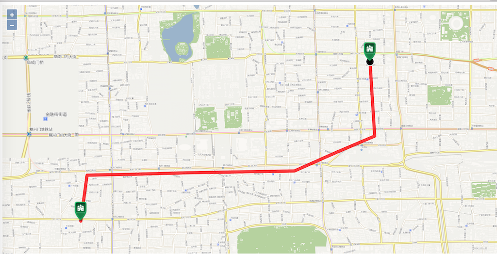
这个例子是按照官方Examples中的Marker Animation来做的,实现了轨迹回放的功能,下面上代码:
<!DOCTYPE html>
<html>
<head>
<title>Marker Animation</title>
<link rel="stylesheet" href="ol.css" type="text/css">
 <style>

      .ol-attribution{

          display:none

      }

 </style>
<script src="ol.js"></script>
</head>
<body>
<div id="map" class="map"></div>
<label for="speed">
speed:
<input id="speed" type="range" min="1" max="999" step="10" value="1">
</label>
<button id="start-animation">Start Animation</button>
<script>
//GIS服务地址
var url = 'http://127.0.0.1:8399/arcgis/rest/services/beijingnewmap/MapServer';
//一组经纬度,用于在地图上打点
var coords = [
[116.429001,39.922701],
[116.430001,39.906901],
[116.422001,39.903501],
[116.413001,39.899501],
[116.390001,39.899101],
[116.379001,39.898801],
[116.369001,39.898601],
[116.367667,39.888861]
]; //轨迹图层
var lineFeature = new ol.Feature({
type: 'route',
geometry: new ol.geom.LineString(coords)
});
//运动点
var geoMarker = new ol.Feature({
type: 'geoMarker',
geometry: new ol.geom.Point(coords[0])
});
//开始点
var startMarker = new ol.Feature({
type: 'icon',
geometry: new ol.geom.Point(coords[0])
});
//结束点
var endMarker = new ol.Feature({
type: 'icon',
geometry: new ol.geom.Point(coords[coords.length-1])
}); //一组样式
var styles = {
'route': new ol.style.Style({
stroke: new ol.style.Stroke({
width: 8, color: [255, 0, 0, 0.8]
})
}),
'icon': new ol.style.Style({
image: new ol.style.Icon({
anchor: [0.5, 1],
src: 'icon.png'
})
}),
'geoMarker': new ol.style.Style({
image: new ol.style.Circle({
radius: 10,
snapToPixel: false,
fill: new ol.style.Fill({color: 'black'}),
stroke: new ol.style.Stroke({
color: 'white', width: 2
})
})
})
}; var animating = false;
var speed, now;
var speedInput = document.getElementById('speed');
var startButton = document.getElementById('start-animation'); var vectorLayer = new ol.layer.Vector({
source: new ol.source.Vector({
features: [lineFeature, geoMarker, startMarker, endMarker]
}),
style: function(feature) {
// hide geoMarker if animation is active
if (animating && feature.get('type') === 'geoMarker') {
return null;
}
return styles[feature.get('type')];
}
}); //将轨迹的中心点设置为地图的中心点
var center = [coords[coords.length/2]];
var map = new ol.Map({
target: document.getElementById('map'),
loadTilesWhileAnimating: true,
view: new ol.View({
projection: 'EPSG:4326',
center: center,
zoom: 14,
minZoom: 2,
maxZoom: 19
}),
layers: [
new ol.layer.Tile({
source: new ol.source.TileArcGISRest({
url: url
})
}),
vectorLayer
]
}); var moveFeature = function(event) {
var vectorContext = event.vectorContext;
var frameState = event.frameState; if (animating) {
var elapsedTime = frameState.time - now;
// here the trick to increase speed is to jump some indexes
// on lineString coordinates
var index = Math.round(speed * elapsedTime / 1000); if (index >= coords.length) {
stopAnimation(true);
return;
} var currentPoint = new ol.geom.Point(coords[index]);
var feature = new ol.Feature(currentPoint);
vectorContext.drawFeature(feature, styles.geoMarker);
}
// tell OL3 to continue the postcompose animation
map.render();
}; function startAnimation() {
if (animating) {
stopAnimation(false);
} else {
animating = true;
now = new Date().getTime();
speed = speedInput.value;
startButton.textContent = 'Cancel Animation';
// hide geoMarker
geoMarker.setStyle(null);
// just in case you pan somewhere else
map.getView().setCenter(center);
map.on('postcompose', moveFeature);
map.render();
}
} /**
* @param {boolean} ended end of animation.
*/
function stopAnimation(ended) {
animating = false;
startButton.textContent = 'Start Animation'; // if animation cancelled set the marker at the beginning
var coord = ended ? coords[coords.length-1] : coords[0];
/** @type {ol.geom.Point} */ (geoMarker.getGeometry())
.setCoordinates(coord);
//remove listener
map.un('postcompose', moveFeature);
} startButton.addEventListener('click', startAnimation, false);
</script>
</body>
</html>
需要注意的是我这里使用的是经纬度,所以在构建地图的时候需要指定坐标系projection: 'EPSG:4326',否则地图是出不来的。
下面的样式是去除地图右下角OpenLayers的logo的:
<style>
.ol-attribution{
display:none
}
</style>
最新文章
- http://www.cnblogs.com/youring2/archive/2011/03/28/1997694.html
- android界面横屏和竖屏的切换
- POJ 1538
- 将字符转换为unicode码
- 为什么用服务不用线程-Android
- what is the virtual machine, when and why we need use it ?
- preference activity框架
- listview滚动到底部
- 【Linux CentOS 在虚拟机中XShell出现: (port 22): Connection failed.】
- div footer标签css实现位于页面底部固定
- php 表单提交大量数据发生丢失的解决方法
- centos6.5环境下的web项目mysql编码方式导致的中文乱码问题
- 基本类型(2):oracle中有4个大对象(lobs)类型可用,分别是blob,clob,bfile,nclob。
- Eclipse 项目有红感叹号
- Android Studio开发-高效插件强烈推荐
- long类型与int类型的转换
- asp.net MVC在IIS7或7.5上的发布问题
- .Net面试经验,从北京到杭州
- VLFeat在matlab和vs中安装
- BZOJ3165 & 洛谷4097:[HEOI2013]Segment——题解