Arcpy处理修改shapefile FeatureClass 线要素坐标
参考资料:
1. 关于坐标转换计算: 在另一篇文章中有参考资料 http://www.cnblogs.com/beautifulplanet/p/4309222.html
2. 如何用arcpy进行处理呢,先找到这个链接
http://gis.stackexchange.com/questions/17096/edit-end-points-in-polyline-python-arcmap10,
从def offsetFirstPointInLine(line_geom,X_distance,Y_distance)函数中找到如何提取每一条线记录的每个点坐标:
geom = r.getValue("SHAPE")

array = geom.getPart(0)
那array 是什么呢?
3. 上面那个例子只处理了每条线的一个点,而我需要对每个点进行处理,那怎么构成其中的new line呢?又去找ArcGIS的帮助,找到PolyLine类
http://help.arcgis.com/zh-cn/arcgisdesktop/10.0/help/index.html#/na/000v000000n2000000/
看看其中polyline是如何由点组装起来的。
解决方案:
经过上面三步梳理,整理代码如下
>>> import arcpy,math

... pi = 3.14159265358979324

... a = 6378245.0

... ee = 0.00669342162296594323

... def transformLat(x,y):

...     ret = -100.0 + 2.0 * x + 3.0 * y + 0.2 * y * y + 0.1 * x * y + 0.2 * math.sqrt(abs(x))

...     ret += (20.0 * math.sin(6.0 * x * pi) + 20.0 * math.sin(2.0 * x * pi)) * 2.0 / 3.0

...     ret += (20.0 * math.sin(y * pi) + 40.0 * math.sin(y / 3.0 * pi)) * 2.0 / 3.0

...     ret += (160.0 * math.sin(y / 12.0 * pi) + 320 * math.sin(y * pi / 30.0)) * 2.0 / 3.0

...     return ret

... def transformLon(x,y):

...     ret = 300.0 + x + 2.0 * y + 0.1 * x * x + 0.1 * x * y + 0.1 * math.sqrt(abs(x))

...     ret += (20.0 * math.sin(6.0 * x * pi) + 20.0 * math.sin(2.0 * x * pi)) * 2.0 / 3.0

...     ret += (20.0 * math.sin(x * pi) + 40.0 * math.sin(x / 3.0 * pi)) * 2.0 / 3.0

...     ret += (150.0 * math.sin(x / 12.0 * pi) + 300.0 * math.sin(x / 30.0 * pi)) * 2.0 / 3.0

...     return ret

... def offsetPoint(wgLat,wgLon):

...     dLat = transformLat(wgLon - 105.0, wgLat - 35.0)

...     dLon = transformLon(wgLon - 105.0, wgLat - 35.0)

...     radLat = wgLat / 180.0 * pi

...     magic = math.sin(radLat)

...     magic = 1 - ee * magic * magic

...     sqrtMagic = math.sqrt(magic);

...     dLat = (dLat * 180.0) / ((a * (1 - ee)) / (magic * sqrtMagic) * pi)

...     dLon = (dLon * 180.0) / (a / sqrtMagic * math.cos(radLat) * pi)

...     new_point = arcpy.Point(wgLon+dLon, wgLat+dLat)

...     return new_point

... def offsetFirstPointInLine(line_geom):

...     new_point = arcpy.Point()

...     new_array = arcpy.Array()

...     array = line_geom.getPart(0)

...     for x in range(0,array.count):

...         old_point = array[x]

...         new_point = offsetPoint(old_point.Y,old_point.X)

...         new_array.add(new_point)

...     new_line = arcpy.Polyline(new_array,SR)

...     new_array.removeAll()

...     return new_line

... fc = r"E:\movedata-lonlat\guodao.shp"

... cur= arcpy.UpdateCursor(fc)

... SR= arcpy.Describe(fc).spatialReference

... print SR

... for r in cur:

...     geom = r.getValue("SHAPE")

...     r.setValue("SHAPE",offsetFirstPointInLine(geom))

...     cur.updateRow(r)

... del r,cur
将处理后的数据再进行Project : WGS 1984 Web Mercator.prj,与谷歌地图进行叠加显示位置一致。
有几句代码标红,是遇到数据缺失的问题后修改的,过程如下:
遇到的问题:
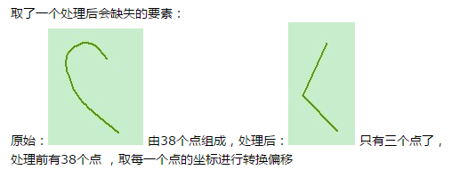
但是...后来放大数据,才发现有缺失,如图(紫色是原始数据,红色是处理后得到的数据)

new_array.add(new_point)
new_line = arcpy.Polyline(new_array)
打印new_array也是38个点,但是打印new_line.pointCount就只有3个点了。
重新分析测试数据(WGS-84 地理坐标系/经纬度 下进行),启用编辑状态,原始的线要素上点比较密集

用 Arcpy Polyline lose points 去谷歌 搜到 http://stackoverflow.com/questions/14248618/shape-information-lost-when-using-arcpy-polyline-object-as-dictionary-value
好像是要添加坐标系,另外又进行了实验:
给这条线加上几个点,其中有几个点距离比较近:
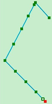
再次处理,线变成了:

推测是不是在构成线的时候有什么距离限制?
用ArcPy Polyline accuracy、 ArcPy Polyline tolerance 谷歌,搜到了http://gis.stackexchange.com/questions/86728/minimum-shapelength-using-arcpy-polyline
其中关键的一句 “ I recommend setting the Geometry's Spatial Reference before inputting the coordinates. The SR has its own XYTolerance and XYResolution”
因此对上面的程序进行修改,增加红色部分。
最新文章
- 浅谈android中的目录结构
- 遍历迭代map的集中方法
- BZOJ4540 [Hnoi2016]序列
- C++设计模式-Command命令模式
- 开发高效的Tag标签系统数据库设计
- Padrino 生成器指南
- Web前端工程师成长之路
- eclipse下开发winform的插件WindowBuilder
- JS函数(获得widn)
- list() and tuple()
- 线程池:ThreadPoolExecutor
- 【分享】改变未来的九大算法[pdf][清晰扫描版]
- Spring 配置文件XML -- <beans>中属性概述
- bootstrap validator html attributes 选项
- Java 异常处理 try catch finally throws throw 的使用和解读(一)
- Hydra(爆破神器)
- mongoengine 分页 切片与 skip + limit 的区别
- EF利用重写SaveChanges()方法实现 审计日志记录
- snmpwalk,iptables
- 多进程编程之system()函数